The Latest Buzz
Hivemapper’s Decentralized Mapping Paves the Way for Smart Cities

Crowdsourced mapping provides dynamic street-level data, empowering cities with fresh insights for sustainable growth.
As urbanization accelerates, the challenges of city planning and management are becoming increasingly complex. Today, 55% of the global population lives in cities, a figure that the World Economic Forum expects to surge to 80% by 2050. This rapid growth, coupled with a pressing need for sustainable and efficient urban environments, has inspired the push toward “smart cities” that use technology and data to optimize operations and improve the quality of life.
At the heart of this concept lies a crucial component: dynamic and up-to-date mapping data. Traditional mapping giants, while impressive in their scope, struggle to maintain up-to-date local coverage that reflects recent changes. Because mapping with a fleet of specialized vehicles is expensive, services like Google Maps often wait years to revisit particular routes and areas.
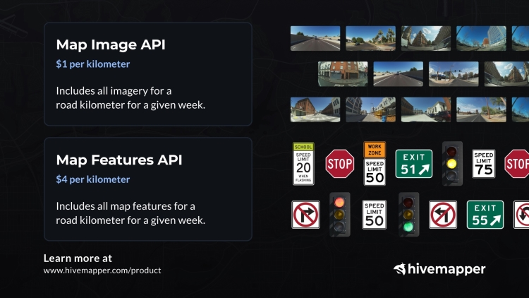
Hivemapper incentivizes a global community of drivers to map with purpose-built dashcams as they drive. Map AI identifies features such as stop signs, speed limits, and traffic lights from street-level imagery, creating a rich dataset that is accessed via APIs.
1. Use our Map Image API to review street-level imagery and assess city road conditions and potential hazards.
2. Use our Map Features API to inventory a city’s speed signs, turn restriction signs, highway exit signs, stop signs, and vehicle traffic lights.
3. Use our Bursts feature to incentivize map contributors to target specific locations in need of updates or monitoring.
4. Use Scout, our location monitoring tool, to set specific locations to be monitored for new imagery and changes.
Visit our product page and contact sales to learn more. To get started, generate an API key.
Learn more at: https://hivemapper.com/product
The Dynamic Data Advantage
By rewarding drivers for mapping their routes as they drive, Hivemapper effectively scales data collection while capturing changes in urban environments over time that traditional mapping approaches would otherwise miss.
This enables city administrators and planners to access dynamic data without having to create the necessary infrastructure themselves — while also protecting privacy. For additional responsiveness, tools like Bursts incentivize on-demand mapping in targeted areas. Hivemapper’s scalable data allows municipalities, regardless of their budget constraints, to easily access the data they need.
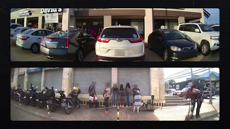
License plates and faces are blurred on the dashcam. Hivemapper contributors uploaded the above images.
Traditional maps, while useful, often present a static view of the urban landscape. In contrast, Hivemapper’s continuously updated coverage can provide a picture of the city over time, tracking everything from new physical developments to changes in traffic patterns.
Dynamic data is invaluable to smart city development. As these centers grow and evolve, so do their infrastructural and operational challenges. A road that was once adequate might become a bottleneck, or a previously overlooked area might emerge as a vibrant community hub. With Hivemapper’s crowdsourced coverage, urban planners and administrators can access relevant insights into these changes, allowing them to make informed decisions and allocate resources more efficiently to improve the lives of locals.
Public Safety and Sustainability
While traffic management is an obvious application for decentralized mapping, the potential of dynamic street-level data extends far beyond it. Consider public safety, for example. By monitoring roads and pedestrian walkways, administrators can identify areas that may require additional lighting, signage, or curb cuts for wheelchair access. This can also help to pinpoint areas where roads are deteriorating or damaged, enabling timely maintenance to ensure smooth commutes for all.
Environmental sustainability can also benefit from this approach. By tracking construction areas as well as changes in green spaces and other natural features, city planners can ensure that urban growth doesn’t come at environmental expense. Detailed street-level data can help guide urban forestry projects, the creation of new parks, and conservation efforts.
Decentralized mapping is also uniquely useful for crisis management. After natural disasters such as floods or earthquakes, established maps may not reflect current conditions. But with continuous updates from sources like Hivemapper, emergency services can have access to more recent data, ensuring that they’re working with the most current information on affected areas, road closures, and potential evacuation routes.
Empowering the Future
Crowdsourced mapping coverage that’s fresh and up-to-date can help provide the foundation on which smarter cities are built. By delivering detailed insights and a continuously refreshed view of the urban landscape, Hivemapper’s innovative approach to mapping can help ensure that the cities of the future are safe, sustainable, and resilient.**
Follow us on X (Twitter) and join the community on Discord.
Share Post


