
The Latest Buzz
Introducing Hivemapper Scout: Your Ultimate Location Monitoring Solution

Empowering map customers with real-time data on the street locations that matter to them.
The use cases for real-time intelligence on street locations are endless. Whether it's monitoring construction sites, ensuring the functionality of critical infrastructure, tracking road closures, or keeping an eye on outdoor billboards, reliable location monitoring is essential. Automotive, navigation, logistics, infrastructure, and insurance businesses, as well as government organizations and nonprofits face two challenges:
- Free street-view products such as Google Street View are wildly out of date. Months, often years out of date. The world changes more quickly than that. You need up-to-date information now.
- If you need anything close to real-time intelligence on a location, you are often sending an actual scout of your own — having an employee drive there, hiring an on-the-ground agent. That's expensive, requires managing personnel, and you don't always have confidence that they are doing a good job or even going to the places they say they are.
Enter Hivemapper Scout — a revolutionary location monitoring tool that gives you real-time data on the street locations that matter to you. Say goodbye to depending on out-of-date images from free "street view" products. Eliminate the need to hire someone to spend hours to visit a single location and take photos. Just mark the real-world locations you care about, and wait for the images to roll in. That's ground truth.
If you need more data, you can put a bounty on your locations using our Bursts feature. In areas with strong coverage, it costs a fraction as much as paying employees or contractors — because Hivemapper Network drivers are already in the neighborhood.
Scout: Open-Source Scout UI Library and Integrated Data
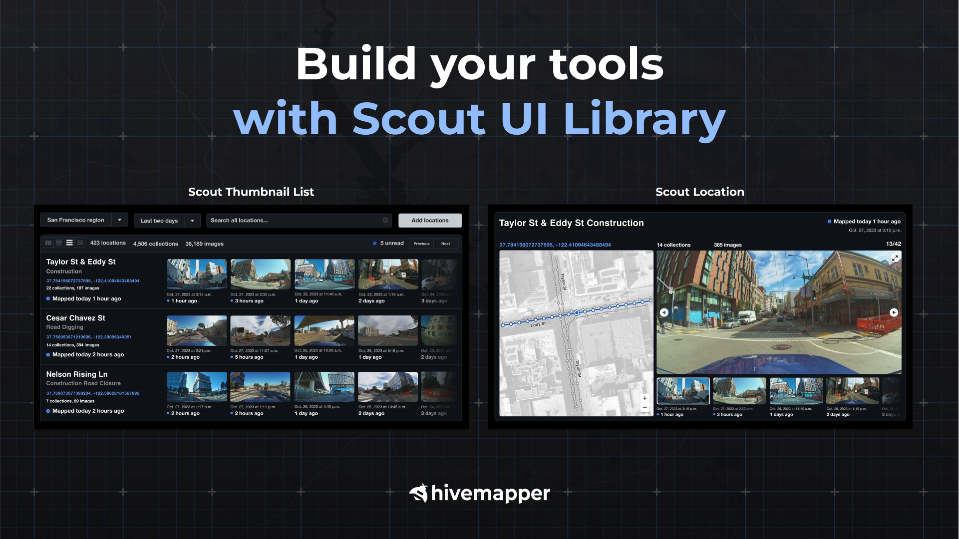
The data that powers Scout comes from the Hivemapper Network via its Map Image API, providing unmatched coverage and freshness. Our Scout UI Library is an easy and fast way to get started with the Map Image API, it’s open source, and available on GitHub. Instead of having to build your own UI elements, you can just plug in UI elements from the Scout UI Library into your applications. You can customize these UI elements for specific needs, host it on your own systems, and seamlessly integrate it into your systems.
Effortlessly Monitor and Track Specific Locations
Using Scout, autonomous vehicle, mapping, local governments, and logistics companies can conveniently monitor and track construction work zones, ensuring that they can operate efficiently and safely.
The tool also provides real-time insights into critical infrastructure, such as cell towers, red-light cameras, and EV charging stations. This equips utility companies and city tech companies to proactively maintain their equipment.
By tracking road closures and providing detailed information on the reasons behind them — be it an event, construction, or police activity — Scout enhances route planning and logistics planning.
Navigate Complex Environments with Ease
Scout’s capabilities extend beyond urban environments. It is adept at tracking critical areas like highway exits and airport loading/unloading zones, which are susceptible to signage changes, lane closings, and reconfigurations. Knowing the operational status of highway exits ensures optimal route planning, while monitoring airport zones helps streamline passenger and cargo logistics.

Observe Your Assets Across Various Locations
Billboard ad brokers, advertisers, and marketers can use Scout to verify the proper display of ads on outdoor billboards, saving time and providing transparency.
Insurance companies benefit from Scout's ability to track specific locations that are prone to frequent changes and high accident rates, assisting with claim processing and risk assessment.
Pricing in dynamic markets at sites like gas stations, parking lots, and highway tolls becomes straightforward with Scout’s real-time data, helping trucking companies make data-driven decisions that maximize profitability.

Try Scout for Free Today
Scout is essentially a strategic partner for businesses, government organizations, and nonprofits operating across automotive, navigation, logistics, infrastructure, and insurance industries. With real-time data and insights, you can enhance your decision-making processes, improve efficiency, and maintain control over your operations and assets. Staying informed and agile has never been more important. With Scout, you can have eyes on the locations that matter to you, and collect the freshest images out there. Try Scout for free today. Contact sales for Map Image API pricing.**
Follow us on X (Twitter) and join our Discord.
Share Post


