
The Latest Buzz
Modern Cars Could Be Building a Better Map

Automotive maps used to be simple: a screen with turn-by-turn directions.
Today’s automotive maps are more than helpful. They’re mission-critical.
The most advanced automated driving systems use maps to compare what they are seeing to what they should be seeing. If a turn-by-turn navigation map is out of date, a driver might just take a wrong turn. With maps for automated driving, lives are at stake.
A mapping industry that formed around navigation use cases is struggling to rise to the challenge.
Deploying dedicated mapping vehicles is expensive, so most mapmakers get updated street-level imagery every year or two – too infrequently to capture roadwork, lane closures and other dynamic elements of a rapidly changing world. Mapmakers try to keep their maps fresh using distributed sensors from automotive modules and smartphones, but the data is often too low-fidelity for safety-critical applications like automated driving.
We see a better way. Modern cars with Advanced Driver Assistance Systems (ADAS) often have cameras on all sides for a 360-degree view of the road. The Tesla Model 3, for example, has eight cameras that watch the car’s surroundings as it drives. Combine these cameras with onboard computing and connectivity, and it is finally possible for cars to form the eyes of a high-fidelity, AI-powered mapping network.
Enabling real-time mapmaking in a small fraction of the 1.5 billion cars on the road worldwide would be enough to build a decentralized, software-defined map to benefit drivers everywhere. A map so rich, so fresh, and so efficient that no automated driving system would go without it.
That’s where Hivemapper comes in. We’re building the end-to-end mapmaking pipeline to make this vision a reality, together with automotive innovators.
4x faster growth than Google Street View
Hivemapper Inc., based in San Francisco, is a Series A startup backed by investors such as Spark Capital, Craft Ventures, Multicoin Capital, VanEck, Founder Collective, and Shine Capital.
Led by mapping (Yahoo! Maps, Apple Maps) and machine learning (Scale AI) experts, Hivemapper piloted its vision of AI-powered distributed mapping with the Hivemapper Network: a community of tens of thousands of contributors using purpose-built dashcams to share map data.
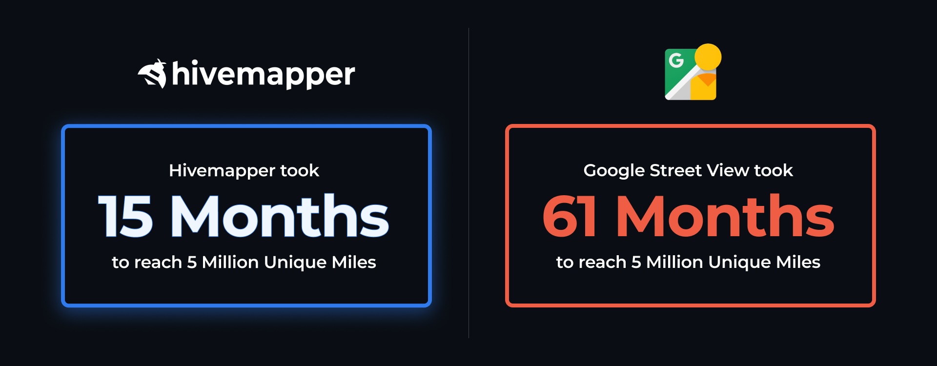
The results are astonishing. In the first 18 months after the launch of the Hivemapper Network in November 2022, contributors mapped more than 200 million km of roads. That included 12 million unique km, or 20% of global roads. Hivemapper has added coverage four times faster than Google Street View did in its early days, making it the fastest growing mapping project in history.
Network imagery gets processed through Hivemapper’s end-to-end Map AI pipeline, which uses a combination of machine learning and human auditing to extract the freshest possible map data. This unmatched freshness has attracted early customers to Hivemapper, including autonomous vehicle developers, rideshare companies, and several of the world’s leading mapping companies.
Purpose-built dashcams are key to the company’s rapid growth, enabling consistent map data quality and a passive collection experience for drivers. One logical next step is an integrated, automotive-grade sensor and computing package, effortlessly collecting standardized and anonymized data for the safety of everyone on the road.
If a driver chooses to support the cause, there’s nothing they need to do but drive.
Purpose-built hardware for precise, passive mapping
Automotive-grade maps require automotive-grade quality.
Hivemapper decided not to use off-the-shelf dashcams or smartphones for a range of reasons, including their inconsistent image quality and positional accuracy. Instead, we designed our camera modules to the exacting specifications of map data customers, laying the technical foundation for future OEM integration.
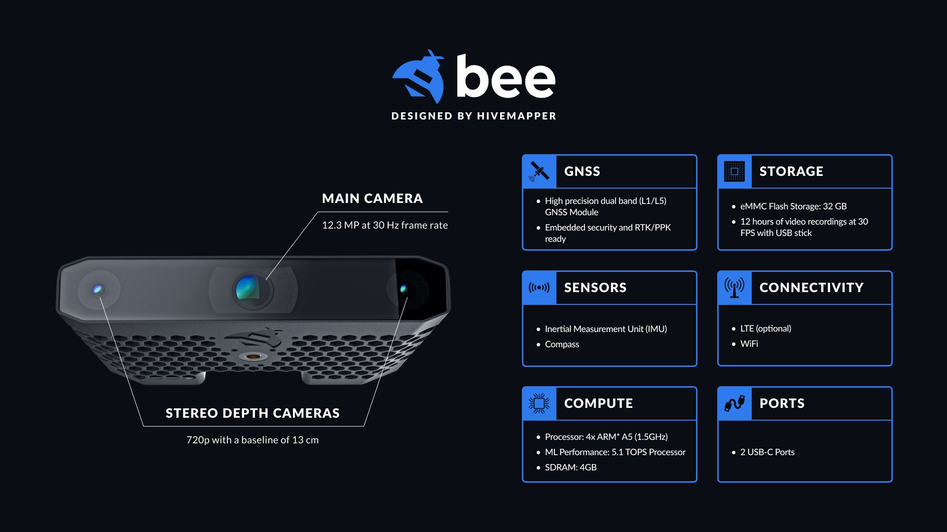
Deliveries of Hivemapper’s third-generation device, the Bee, start in Q3 2024. Priced around $500, the Bee is a premium dashcam that automatically detects vehicle incidents and stores footage for later use. It’s also a precise and passive mapping machine that can effortlessly update the world's freshest map at a small fraction of the cost of a rooftop-mounted mapping rig.
The specifications of the Bee are more like an Advanced Driver Assistance Systems (ADAS) module than a typical dashcam. Here are some of the key features and functions:
- Great positioning. The Bee has a larger antenna than a typical consumer device for more precise baseline positioning, along with a dual-band (L1/L5) GNSS chip that offers better support for RTK/PPK corrections than a consumer device.
- Stereo camera. Detecting a street sign isn’t useful if you can’t say precisely where it is. Stereo cameras make this job far easier. With a wider baseline between cameras than any smartphone, the Bee can judge depth like human eyes or an ADAS module can.
- Passive experience. Mapping needs to happen automatically in the background to be scalable. Once mounted, the Bee automatically uploads map data to the cloud.
- Privacy. Hivemapper dashcams protect drivers and bystanders with on-device blurring that goes beyond faces and license plates to entire bodies and vehicles. Contributors are anonymous, known only by a random three-word username.
- Edge processing. Performing computer vision tasks such as object detection, classification, and positioning on the dashcam dramatically reduces cloud computing and storage costs.
- Connectivity. When building a real-time map with dynamic elements such as an obstacle blocking a road, it’s critical to quickly communicate with the cloud to update the map. The Bee includes an onboard cellular connectivity option for the most passive experience.
With a preorder list of more than 30,000 dashcams prior to launch, the future is bright. But in the not-too-distant future, we will develop a similar hardware and software package for automotive platforms – likely sharing components with a forward-facing ADAS module.
A software-defined AI mapmaking engine
When we use a modern digital map, it feels like wizardry. In reality, tens of thousands of humans are working anonymously behind a digital curtain to build those maps for us.
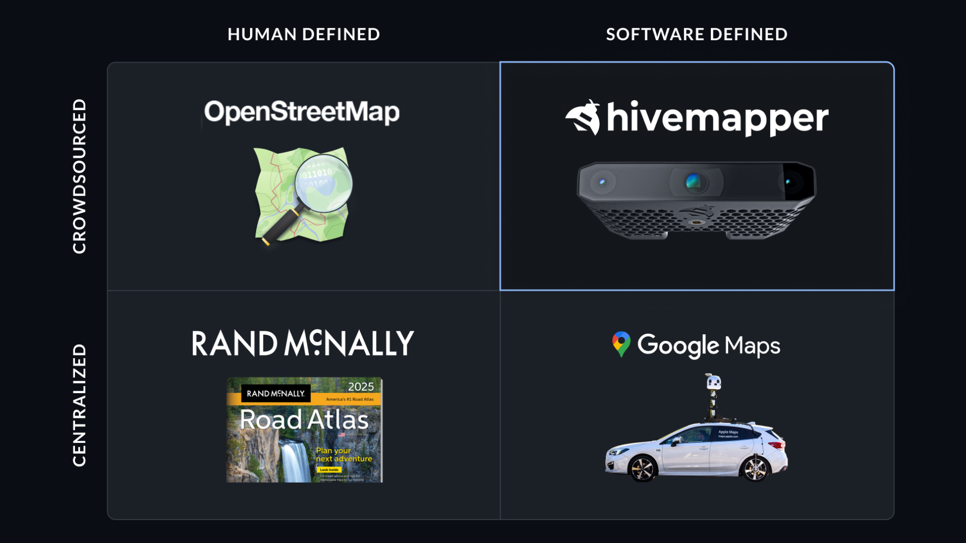
Most of today’s maps, whether built by a trillion-dollar tech company or a community-driven initiative such as OpenStreetMap, rely on complex and monolithic map editing tools. These tools require humans to look at satellite or street-level imagery and draw lines and symbols to represent the roads, traffic signs and natural features that make up a map.
It is painstaking work. That’s why Hivemapper is pioneering a different approach, which we call Map AI. Our approach combines the scalability of computer vision and machine learning with the subtlety of human judgment to dramatically reduce mapmaking costs.
Rather than asking a human to do complex tasks, Map AI breaks them down into simple, bite-sized tasks. Simplifying tasks makes it easy for anyone to get started, and helps users (we call them “AI Trainers”) stay engaged by allowing them to easily switch between tasks for a change of pace.
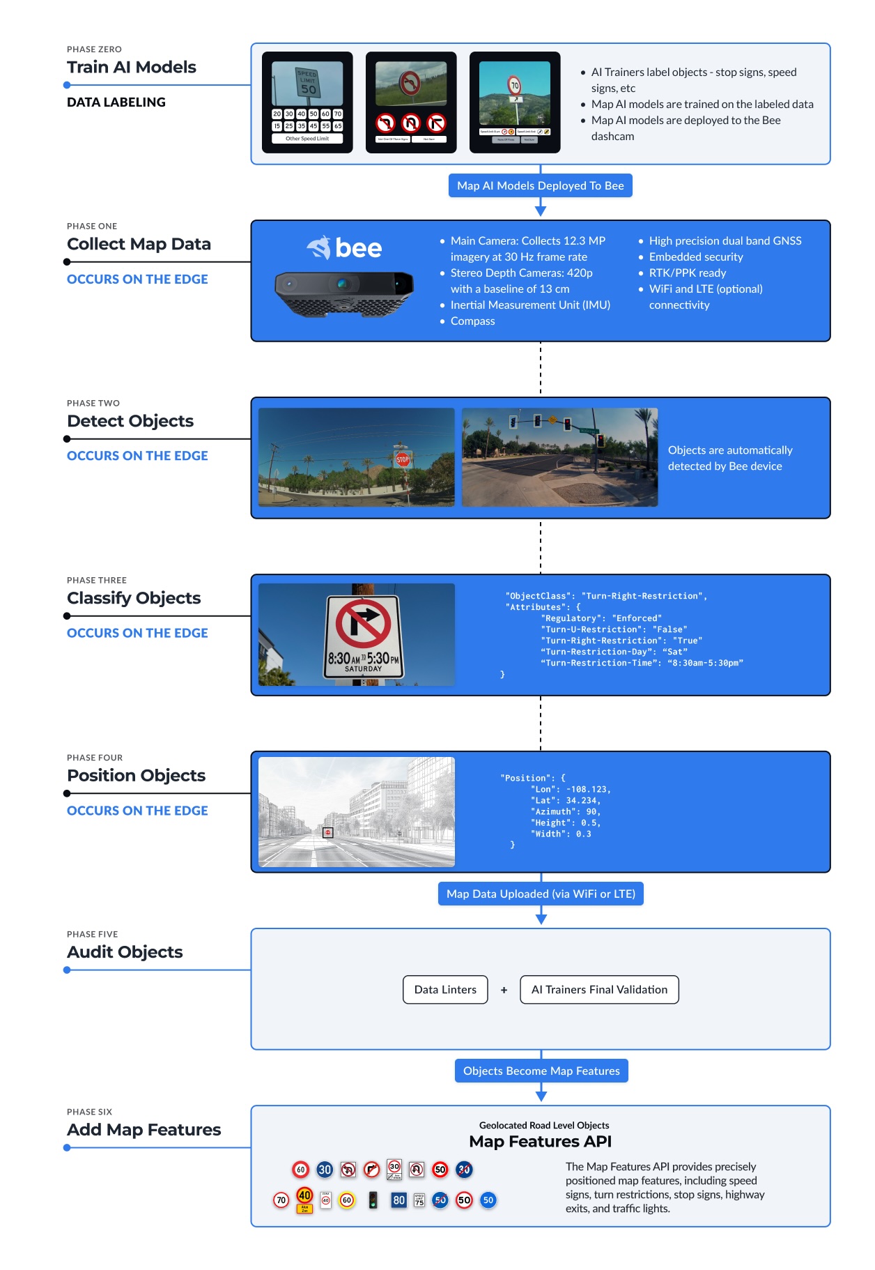
A human AI Trainer might be responsible for confirming how the computer vision algorithm is classifying objects (“Is this speed limit correct?”) or confirming how a 3D reconstruction pipeline is positioning and orienting objects in space. The human can override the AI and make manual adjustments as necessary, such as making sure a turn-restriction sign is assigned to the correct lane. AI is powerful, but it isn’t ready to fully replace human judgment.
The crowdsourced online AI Trainer platform is similar to the data annotation platform that Scale AI uses to improve model accuracy for autonomous vehicle developers, but it is solely focused on fresh and accurate map data.
Since the launch of the Map AI pipeline in 2023, Hivemapper has built a community of more than 30,000 active AI Trainers handling 5 million tasks per day – demonstrating a scalable model for processing and auditing the map data that will soon be generated on the edge by millions of cars.
Meeting the needs of autonomous vehicles and ADAS
As an example of the power of Hivemapper’s approach, consider maps for automated driving. Some experts argue that humans drive without detailed maps of the world in their heads, so automated vehicles don’t need maps. We strongly disagree.
Without detailed and updated maps, vehicles rely solely on real-time sensor data to interpret their environment. This limits their ability to "see" beyond the sensor range, reducing the vehicle’s ability to anticipate road conditions, lane changes, and other navigational challenges.
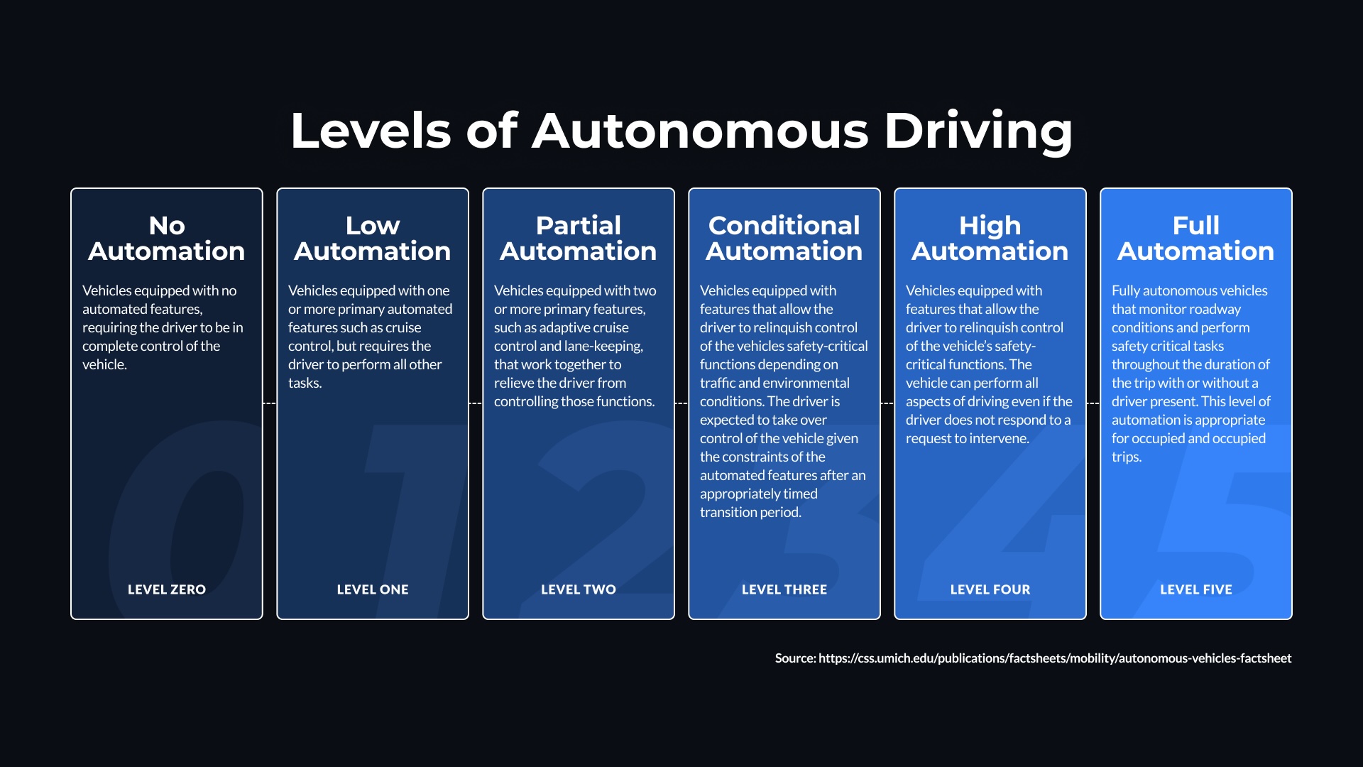
Mapless autonomy may be viable for ADAS systems up to Level 2. But we simply do not believe a fully hands-off automated driving system will receive society’s blessing without fresher, more accurate maps – and not just of a limited set of highways, but everywhere.
Driving scenarios that involve intricate maneuvers, such as navigating roundabouts, merging on highways, or driving through construction zones become far more challenging without detailed map data. Maps provide crucial context that helps systems understand the broader environment, enhancing their decision-making capabilities.
These are a few of the specific use cases where the freshest map data is essential:
- Precise Navigation and Maneuvering: Lane-level mapping allows automated driving systems to understand the exact layout of the road, including the number, orientation, and width of lanes. This is vital for lane keeping and safe lane changes.
- Construction Roadwork: our maps can identify and report changes in lane availability, such as when lanes are closed due to construction. This real-time information helps autonomous and assisted driving systems adjust their navigation strategies accordingly, ensuring they can guide vehicles through reduced lane paths safely.
- Navigation in Adverse Weather: Our maps contribute to safer navigation in poor weather conditions by providing detailed information about road layouts and infrastructure that might not be visible to sensors and cameras during fog, heavy rain, or snow.
- Road Closures: When highway exits or roads are closed for accidents, flooding, events, etc. our maps can rapidly alert the ADAS and autonomous fleets.
- Specialized Road and Lanes: Certain lanes and roads can only be used by certain vehicles — carpool, electric vehicles, commercial vehicles — during specific times of the day. Our maps provide detailed information on specialized road and lane information.
Even if it’s possible to build a mapless system, it will face an inherent disadvantage against a comparable system that uses a map to avoid or navigate these scenarios. Such a performance gap won’t be taken lightly by society when the cost is measured in human lives.
We believe the future will favor automakers and suppliers that take a responsible approach to autonomy. It won’t be a mapless future, but a future with richer, fresher maps than we’ve ever had before, made possible by the billions of roving sensors on wheels that we commonly call cars.
Connect with Hivemapper and build the maps of the future.
Share Post


